Digital’s digest – This new post series gives you a weekly overview about new exciting geo-, project- and gis-links. We should write about a special link? Please submit it in the comments.
Find former tips here:
Digital’s digest 1 to 5
6. Compare Google with OSM mapstyles on sauter.com
If you want to compare different webmap styles (background tile services) you can whether use mapcompare or the hint of Simon Schmidt: sautter.com. Within an open layers framework you’re able to chose a ground layer (Google Streets, MapMaker, Aerial, Physical) and overlay this with open data mapstyles like OSM Mapnik, Mapnik german style, OSM CycleMap, Mapquest, Hillshading, Hiking Map and the ADFC Bicyclenetwork. With a transparency shifter you can fade the overlays opacity from 0 to 100 % and see clearly the differences between the styles. Check out the pictures.
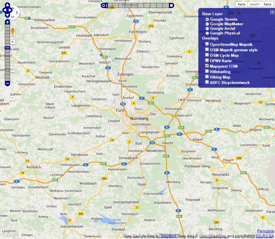
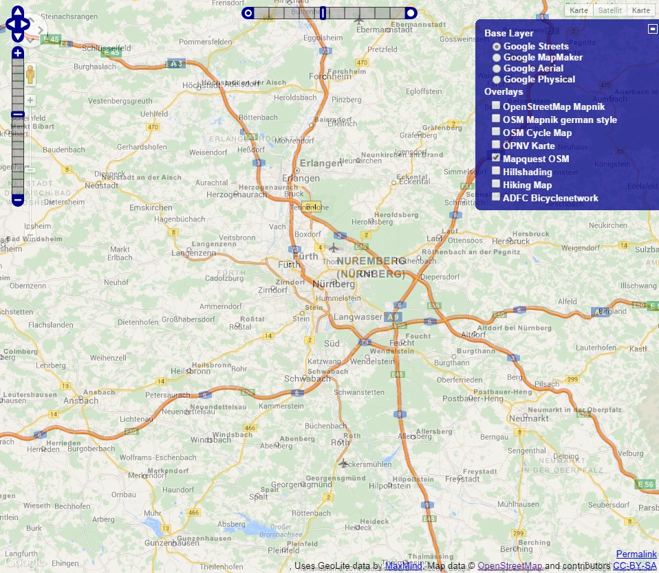
Follow the Link to do your own comparison.
7. Balloon and Kite Mapping Kit + Map Knitter
Remote sensing is an expensive thing to undertake. With raising UAV technologies and a growing community little companies and mapping addicts can afford UAV imagery shots with cheap hardware as well. Particularly the Balloon and Kite Mapping Kit from PublicLab is a really nice project in my opinion. With this kits you can build your own DIY (do it yourself) mapping balloon or kite and get a camera for mapping issues in the air. With the related software Map Knitter – “Turn images into maps” taken pictures could be stitched and processed as real aerial imagery.
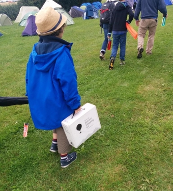


Follow the link to get more information about balloon / kite mapping and the image processing webtool mapknittr.
8. Rectify maps online
You’ve got (old) paper maps? Maybe it would be interesting to use them in a GIS or as a georeferenced image for certain ideas! Mapwraper.net from the New York Public Library is a free and open source georectification and map hosting service. By the way you can browse about 2600 georectified and unrectified maps, upload your own maps and find some overlays (vector data). Additionally there is the possibility to export maps as GeoTiff, rectified PNGs, KML, WMS and !!! as Tiles. I think it’s a great idea and a nice collection, please go on mapwraper.net.
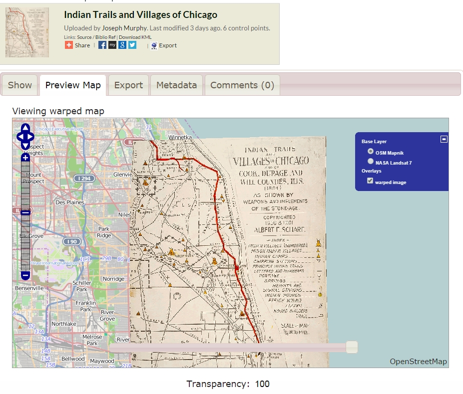
Try the free rectification service here!
9. Load OSM Tiles in QGIS
Inserting an OSM background layer in QGIS isn’t that hard with the well-known OpenLayers Plugin. If you want to show some custom tiles from your own server for example, you need another way to load this tiles into QGIS. GDAL shows a dummy and gives help to write a xml-file to create your own GDAL WMS raster-tile file, which streams your tiles into QGIS. Have a look at the code or use this example (save it to a xml-file and import it as a raster-layer in QGIS)!
<GDAL_WMS>
    <Service name="TMS">
        <ServerUrl>http://tile.openstreetmap.org/${z}/${x}/${y}.png</ServerUrl>
    </Service>
    <DataWindow>
        <UpperLeftX>-20037508.34</UpperLeftX>
        <UpperLeftY>20037508.34</UpperLeftY>
        <LowerRightX>20037508.34</LowerRightX>
        <LowerRightY>-20037508.34</LowerRightY>
        <TileLevel>18</TileLevel>
        <TileCountX>1</TileCountX>
        <TileCountY>1</TileCountY>
        <YOrigin>top</YOrigin>
    </DataWindow>
    <Projection>EPSG:900913</Projection>
    <BlockSizeX>256</BlockSizeX>
    <BlockSizeY>256</BlockSizeY>
    <BandsCount>3</BandsCount>
    <Cache />
</GDAL_WMS>
10. High Road OSM filter
Styling the awesome datasets from OpenStreetMap can be hard if you want to have a compromise between seamless line-networks and a generalized mapping. To get a proper result you’ll need good filter and styling rules. There are some general approaches like OSMBright and specific ones like our “Digital’s digest” nr. 10 – the High Road OSM query.

When you have some interesting experience (finished projects) with this approach of road styling, please comment. Here you get to the HighRoad OSM query made by migurski.
I really like the idea of the Ballon Mapping Kit. Wish to have one for my own =)