For a geomorphological study that I am working on I want to produce topographic swath profiles across a mountain range, that is, I want the average elevation along a profile plus the min and max values within a certain distance of said profile. I have used three different methods to achieve that and found some nice resources that I’d like to share with you:
GMT – Generic Mapping Tools
GMT is a powerful suite of command-line small programs to manipulate all kinds of geographic data (Wessel and Smith, 1998; Wessel et al., 2013). A walk through on how to produce swath profiles can be found here: http://www.geo.uu.nl/~wwwtekto/gmtexamples/ex01/gmt_example_01.html. This is a bit advanced, but I like the results a lot and I am doing most of my maps with GMT anyway. This is an example of swath data that I produced with GMT4 (thanks to Andy!):
QGIS – swath profile plugin
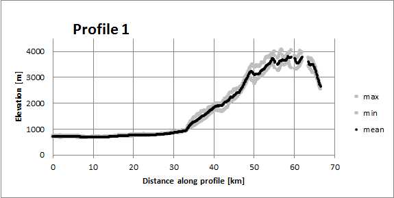
This plugin seems to have a few bugs (it keeps on crashing for some of my profiles) but it does a pretty good job once you got used to it. It seems to be a bit counter-intuitive that the profile you start with is perpendicular to the orientation of your elevation profile, but it makes sense if you think about it. Main advantage for me is that it works in the QGIS environment that I use for some of my maps and that I can feed any DEM to the plugin (this also works in GMT, though…). I save the swath data as *.csv files and then produce the graph with other programs. You can easily use Excel to make a figure like this:
Generalized Swath Profiles online tool by Stefan Hergarten
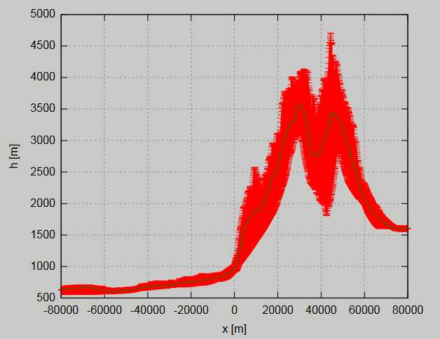
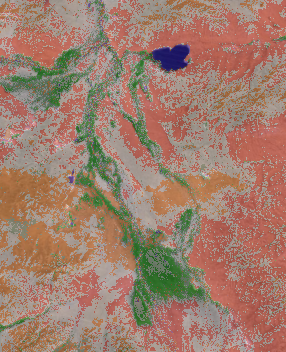
In this paper Hergarten et al. (2014) describe how to produce swath data across curved geomorphic features. Stefan Hergarten set up an online tool to produce swath profiles and to export the data for further analyses. The downside is that he implements only a few datasets and the most recent high-res ones are missing (SRTM1, JAXA ALOS 30 m). On the plus side, however, this is a great free tool and very easy to use. Cheers to Stefan for this great resource! This is what the raw data might look like:
Plus, here a descriptions on how to use ArcGIS for swath profiles:
- http://gis4geomorphology.com/swath-profile-elevation/
- https://sites.google.com/site/sorsbysj/geospatial-processing/geospatial-analyses/swath-profiles
- http://www.geos.ed.ac.uk/~smudd/LSDTT_docs/html/swath_profiles.html
A solution in R:
References:
- Hergarten, S., Robl, J., & Stüwe, K. (2014). Extracting topographic swath profiles across curved geomorphic features. Earth Surface Dynamics, 2(1), 97.
- Wessel, P., & Smith, W. H. (1998). New, improved version of Generic Mapping Tools released. Eos, Transactions American Geophysical Union, 79(47), 579-579.
- Wessel, P., Smith, W. H., Scharroo, R., Luis, J., & Wobbe, F. (2013). Generic mapping tools: Improved version released. Eos, Transactions American Geophysical Union, 94(45), 409-410.

I recommend the interactive swath tool from SAGA. Saga comes for free with QGIS, and this tool produces lines, points and a table including mean/min/max and a range of 1 standard deviation around the mean value. The only problem: you have to deal with SAGA and its .sgrd-grids.