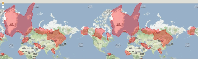
A lot of articles here at Digital Geography deal with maps and projections. You may have wondered how wrong the different map projections are or let’s say, what they lead us to think how big some areas on earth might be. Well, I can not tell you exactly, but the Mercator Puzzle gives you an idea on the errors that we need to deal with. Plus, it’s fun. Drag the outlines and fit them to countries: The Mercator Puzzle by Google. (To be honest, I expected myself to perform better…)
short announcement: The Mercator Puzzle
- Post author By Christoph Grützner
- Post categories In Studies & Basic Concepts
done 15 out of 15 😉
Me too, but it took some time!
[…] | Vía Digital Geography | […]