The Fall Meeting of the American Geophysical Union is one of the largest annual gatherings of scientists. Some 22000 have descended on San Francisco to discuss topics from the magnetosphere and heliosphere to river erosion mapping using airborne laser scanning and the use of GRACE for water budget estimation in the Colorado River basin. Here some of my highlights from the first half of the meeting:
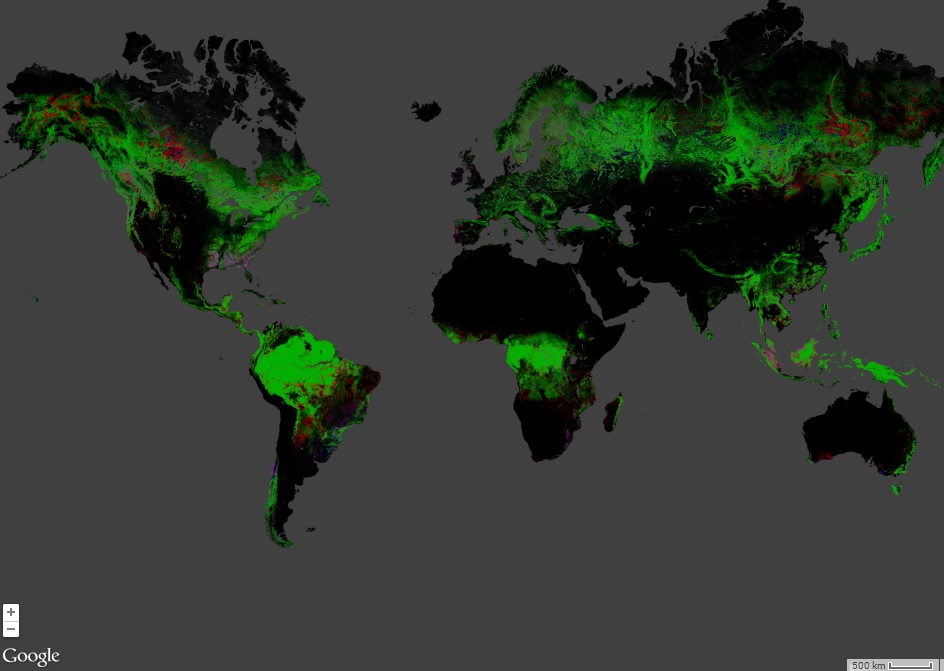
- Google is coming (cheer or run for cover as appropriate). Google have laid out their new Earth Engine, an online, in the cloud, satellite image processing system. Yup, they really are taking over the World. Earth Engine includes a range of MODIS products, over half a million Landsat scenes and a host of digital elevation data. You can display, classify, perform image arithmetic and more. Earth Engine was used for a study by Hansen and colleagues wh estimated the extent of global deforestation published this year in Science. It even made the news. Google Earth Engine is sure to put the cat among the pigeons by providing free tool with masses of computational power, that is scalable and adaptable. It may not challenge the likes of ERDAS and ENVI but it must worry some of the smaller players. Watch this space.
- Snow! There has been a lot of talk about snow. Tom Painter and colleagues from JPL have held several presentations outlining the operations and results of their Airborne Snow Observatory. The ASO uses LiDAR and multispectral imaging to estimate snow depth, from which snow water equivalent (SWE) is estimated, and to calculate radiation fluxes for melt modelling. Jeff Dozier presented work on using backward energy balance modelling and MODIS data to estimate melt in the Hindu Kush. Other presenters included Carrie Vuyovich and Jennifer Jacobs talking about problems in retrieving snowpack parameters from passive microwave data for flood forecasting in the Great Plains and Jóse Infante who illustrated the use of the ArcSWAT hydrological model for snow runoff modelling.
-
Deltas δ. Lots of posters have been presented on all aspects of deltas and coastal (eco-)systems. Many use remote sensing. Andrea Taramelli showed an impressive optical-SAR approach to integrated monitoring which included the use of interferogram stacking to estimate subsidence. The project aims to roll out an operational monitoring service under the EU Copernicus umbrella. Ian Harrison’s poster outlined the results of multi-temporal L-band SAR observations of mangrove dynamics using JERS-1 and ALOS PALSAR data. Lots of work looked at sea level or climate impacts on ecosytems and local populations.
So that’s just a taster. More to come later, but now I am off to listen to Compton J. Tucker present a new improved multi-decadal time series of vegetation index (NDVI) imagery.