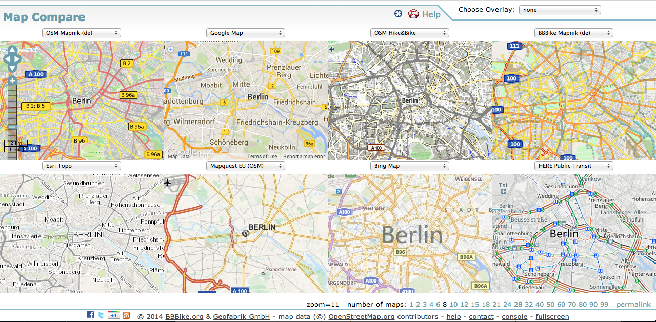
Driven of the high usability of webmaps for companies and projects, many background-styles are available online. The existing styles can be easily implemented in your own project-map. Depending on the thematic map approach it’s appropriate to use a topographic, minimal-graphic or thematic reduced map-style to get the best basemap as groundlayer for your overlaid vector-data. The webapp “Map Compare” made by Wolfram Schneider makes it easy to compare available basemaps and cartographic styles and is one of my favorite “smart tools” for digital mapping projects.
Map Compare, currently in version 2.9, shows up to 99! map windows with different basemaps in the same map extend. Of course you can scroll and zoom as normal (Picture 1 – 8 windows).
An overlay function allows to show some styles overlaid on the activated basemaps (Pic 2).
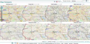
From a menu you can choose the offered basemap-styles and add them to the map windows. Also there are some special overlays like ASTER GDEM height model or some foreign labelsets which can be shown upon your current basemap-selection.
The webapp shows coordinates and zoom-level which makes navigation easy.
Which basemaps you can compare?
(excerpt from Map Compare help)
| BBBike | BBBike data rendered with Mapnik for Berlin from BBBike.org server |
| BBBike Smoothness | BBBike data for Berlin rendered overlay for street quality |
| OSM Mapnik | OpenStreetMap data rendered with Mapnik from official tile server, or in German style |
| OSM Mapnik (b/w) | OpenStreetMap data rendered with Mapnik black/white style from official tile server |
| OSM Hike&Bike | OpenStreetMap data rendered with Hike&Bike style |
| OSM CycleMap | Cycle map based on OpenStreetMap data, by opencyclemap.org |
| OSM Landscape | OpenStreetMap data rendered with Landscape style, by opencyclemap.org |
| OSM Transport | OpenStreetMap data rendered with transport style, by opencyclemap.org |
| OSM Public Transport | OpenStreetMap data rendered with public transport style, by öpnvkarte.de |
| Hillshading SRTM3 V2 | SRTM3 data rendered, by toolserver.org |
| Land Shading | OpenStreetMap data rendered with Land Shading style, by openpistemap.org |
| OSM labels | OSM labels Russian, Japanese etc., by toolserver.org |
| Toner | Toner, Watercolor, based on OSM data, by stamen.com |
| Mapbox (OSM) | OpenStreetMap data rendered with MapBox style, by MapBox.com |
| street map, satellite and aerial photos, and physical map, by Google |
|
| Yahoo | street map, satellite and aerial photos, by Yahoo |
| Bing | street map, aerial and hybrid map, by Microsoft |
| MapQuest Map | street map, satellite, by MapQuest |
| HERE | HERE Map, Terrain, Satellite, Hybrid, Public Transit, Traffic, by HERE / Nokia |
| Esri | street map, topological map, by Esri |
| Apple | Apple iPhoto maps, based on OSM data |
| MapBox | MapBox maps, based on OSM data |
| Skobbler | Skobbler maps, based on OSM data |
| Wanderreitkarte | Wanderreitkarte Ride & Hike, based on OSM data |
| Soviet Military | Soviet Military topografic map from ca. 1985, hosted by Atlogis |
| Maptookit Topo | Maptookit topografic map, based on OSM and SRTM data, by Maptoolkit.net |
| OpenTopoMap | OpenTopoMap topografic map, based on OSM and SRTM data, by OpenTopoMap.org |
| Cloudmade | Cloudmade map, based on OSM data, by Cloudmade.com |
| Waze | Waze map, by Waze.com |
| overlays | OSM based overlays: ADFC Radwegenetz, Velo-Layer, MaxSpeed, Parking, Power Map, Bicycle Network |
| OSM2World | OSM2World 3D map, by osm2world.org |
| map1eu | map1eu print map, by map1.eu |
| Falk | Falk OSM map, by falk.de |
| Lyrk | Lyrk OSM map, by lyrk.de |
| Komoot | Komoot OSM map, by komoot.de |
| OpenMapSurfer | OSM Administrative Boundaries, ASTER GDEM by uni-heidelberg.de |
| OSM FR | OSM France by openstreetmap.fr |
| Waymarkedtrails | OSM Waymarkedtrails for hiking, cycling, MTB and skating, by waymarkedtrails.org |
Here you are: Map Compare
Follow this link to get to Map Compare: http://mc.bbbike.org/mc/
You need an individual basemap
In some cases the common basemaps don’t fit to special interests and project goals. Thats’s why we create individual style for your needs. Please contact us, if you are interested.
