Google’s Earth Engine offers spatial researcher-tools in combination with their huge amount of collected satellite data. In fact you have the possibility to access e.g. 40 years of LANDSAT-data (of course for free) and show it in your browser-worspace. But this is just the beginning. Explore detection of deforestation, landcover classification, biomass and carbon estimates and much more.
Featured timelapse views
On the homescreen on google’s earth engine page you will find some nice featured items. The Landsat Annual Timelaps from 1984 to 2012 gives you an idea about the information-power of spatial data.
Google prepared different views:
- Growth of Las Vegas, Nevada
- Wyoming Coal Mining, Western U.S.
- Saudi Arabia Irrigation
- Drying of Lake Urmia, Iran
- Amazon Deforestation, Brazil
- Columbia Glacier Retreat, Alaska
- Duabi Coastal Expansion
- Drying of the Aral Sea
Precomputed datasets
Further on there are precomputed datasets. Have a look at:
Data Catalog
After this little introduction you can search for data in the earth enginge data catalog. Sortet by tags like refresh period or sensors you also can “google” you data needs. Also new products, like the Landsat 8 data, are included. Also processed data is available!
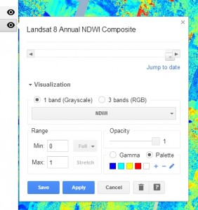
Workspace
The really cool thing about the goolge earth engine is the build in workspace. Here you can easily add data from the data catalog and show it on a google map. The following pictures give you an impression. Every layer has a configuration menu to adjust some preference.

Give it a try and have fun witg google’s earth engine: http://earthengine.google.org/#intro
More about satellite data:
unfortunately, the precomputed data sets would only be displayed in windows or mac, as there’s no google earth plugin for *nix