I’m always looking for good sources of free data, so I thought I would post a few here in case they were useful to others. The sources listed below tend to be larger providers of regional to global level data, however, please post suggestions in the comments if there are other sources you like and think should be added. I had initially planned to include vector data here, but I think that will be another post as this one got quite long.
SAR Data
Free Synthetic Aperture Radar data can be some of the hardest to find, but it is out there if you look hard enough. These products are often provided in CEOS or other formats and there are a variety of tools available for working with the data. Some of the more common tools are ASF MapReady, The Next ESA SAR Toolbox, and PolSARPro. Each of these supports certain datasets and not others. NEST also supports interferometry for the ESA-provided SAR data sets through an interface to the DORIS package from Delft University.
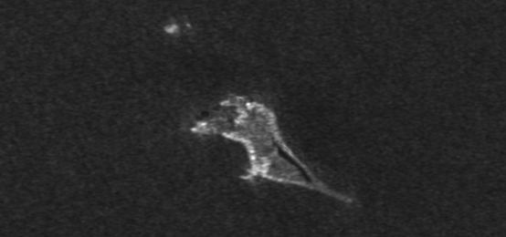
UAVSAR
This one is pretty close to home for me. The Alaska Satellite Facility at the University of Alaska Fairbanks is the distributor of data from NASA’s UAVSAR mission. This airborne platform is fully polarimetric and also offers a repeat-pass interferometry product. These products are available free of charge to all users.
Links:
UAVSAR Website at JPL
Search UAVSAR data at ASF
PALSAR Mosaics
These products were generated as part of JAXA’s Kyoto and Carbon project and come in two forms, a 50m orthorectified mosaic and 500m browse mosaics. They are derived from dual-polarization PALSAR and may be useful for forest mapping and regional studies, particularly in the tropics.
Links:
JAXA Kyoto and Carbon Mosaics
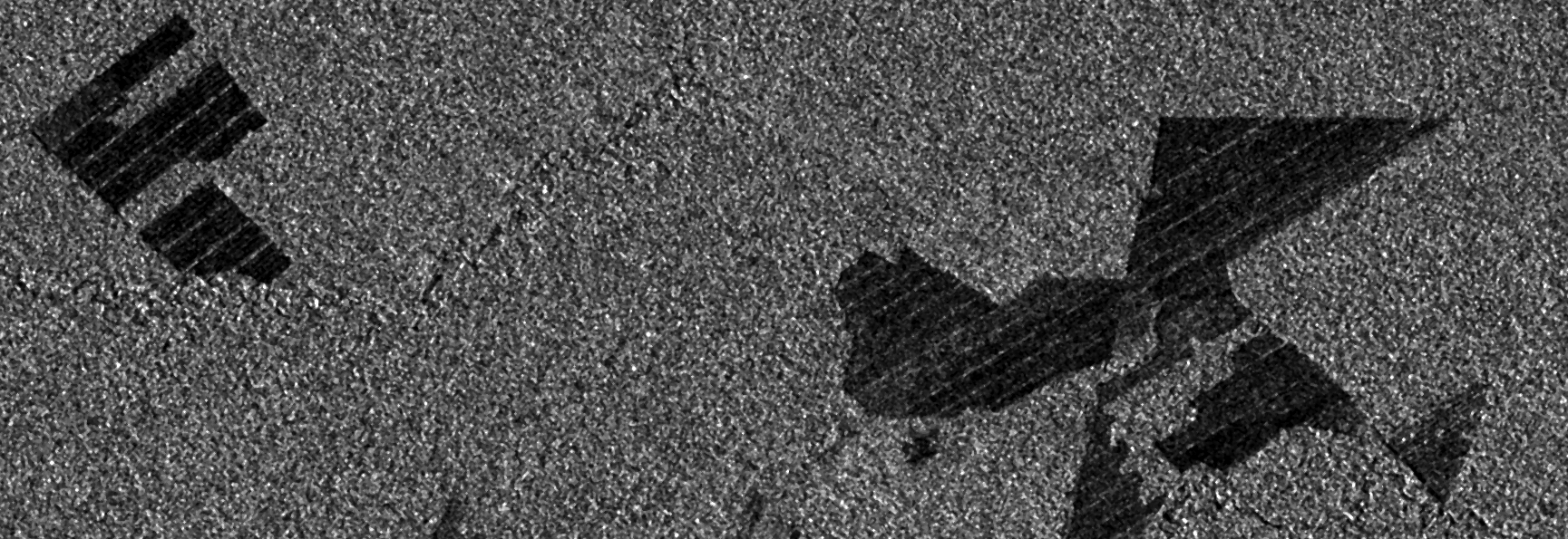
ERS/Envisat @ ESA
ERS-1/-2 and Envisat were launched and operated by ESA and supported a wide variety of applications during their lifetimes. For commercial purposes, the products are available from a variety of resellers, however, if you are a researcher you can get access to data at no cost. It does require you to submit a small proposal to ESA for access to data, but the process is relatively simple and ESA’s user support is very helpful if you have problems.
Links:
ESA PI Portal
Optical Data
There are many resources available for free or public domain optical data. In the U.S., the best of these are the USGS and NASA. Both offer vast archives of data, generally at no cost to the user.
EROS Data Center
EROS Data Center (EDC) is the primary data center operated by the USGS. It houses an enormous archive of everything from high-resolution optical imagery to the complete archive of Landsat imagery. Their archive is global in nature and free to the public, however, you will need to create an account (free) to download data. Their search and download client, EarthExplorer, is easy to use and the best way to find data at the USGS is just get on EarthExplorer and start working through the many data sources available. No one knows for sure when Landsat 8 data will be available in EarthExplorer, but hopefully this summer we will start seeing this exciting new dataset.
Link:
USGS EarthExplorer
Global Land Cover Facility (GLCF)
GLCF is a great site for land cover data, primarily Landsat data. However, they also host DEM data from SRTM and isolated other data sets. If you are a Landsat user, this is definitely a place to bookmark.
Link:
GLCF at University of Maryland
Global Change Master Directory (GCMD)
GCMD is not itself a provider of geospatial data, but they act as a metadata clearinghouse for many data providers around the world. You won’t get access to data at GCMD, but you can find who provides access to the data.
Links:
Global Change Master Directory
MODIS @ NASA
The MODIS sensors, on NASA’s Aqua and Terra spacecraft, have been collected ocean and land surface data for over 10 years. While the pixels are large (250m), the swath is also large and so vast areas are imaged regularly with these sensors. NASA distributes the image products as well as a variety of Level 2, 3, and 4 products derived from this rich dataset.
Links:
MODIS at NASA
MODIS Land Products
MODIS Cryo Products
MODIS Ocean Color and Sea Surface Temp Products
MERIS @ ESA
Similar to MODIS, MERIS on Envisat provided over a decade of multispectral imaging at moderate resolution. These data are also available from ESA free for research purposes through the ESA PI Portal. Through this portal you can also gain access to a host of other products, from both ESA and 3rd party missions.
Links:
ESA PI Portal
Elevation Data
Elevation data are becoming more and more used in geospatial analysis. Sadly, there is yet to be a global, high-resolution DEM that is widely available at no cost. There are a few isolated sources of high-resolution data, but most areas are still not covered.
SRTM
The Shuttle Radar Topography Mission (SRTM) was an imaging radar system that flew aboard the U.S. space shuttles. Using SAR interferometry, it was possible to generate a very accurate DEM at 30m posting. However, these data are only available for the U.S. below 60 degrees latitude. The rest of the world is covered at 90m posting. While very course, this is still the best available product in many parts of the world.
Links:
SRTM at JPL
SRTM Data at USGS
OpenTopography.org
While very limited in scope, the lidar-derived DEM data at opentopography.org is some of the highest resolution, publicly-available elevation data in the world. If your area of interest includes the contiguous U.S. and you are using elevation data it is worth checking this site for data availability.
Links:
Open Topography
Canada GeoBase
I’m not a regular user of GeoBase data, but I did use it recently for DEM data for an orthorectification project in Canada. The interface was pretty easy to use and I was able to get what I needed. There catalog looks very comprehensive for Canada and I know they offer access to the Canadian Digital Elevation Dataset (CDED). Website available in both English and French.
ASTER GDEM2
The ASTER GDEM2 is a global elevation dataset derived from the Japanese ASTER sensor aboard NASA’s Terra spacecraft. Given the bilateral nature of these data and the processing effort that went into the product, they are offered for download by both the U.S. and Japanese governments. The GDEM is a nice product in many areas, however, in my own work I have found many locations where the GDEM has significant artifacts or large errors. While they may work great for you, I would recommend careful examination of these data before using them in your projects.
Links:
ASTER GDEM has links to the various locations to download these products.
This is by no means a comprehensive list of the free data resources available on the Web. I have only highlighted a few of the larger, or more unique, sources. There are a host of smaller providers who do a great job providing free data for smaller areas, from the town and village level through the state/province/prefecture level. Seek them out and if you find them useful, let us know so they can be included in the future.
I hope you find this information useful and, as always, thank you for reading.
Some of my recent posts
Reading Geospatial Data with Python
QGIS Plugin – RasterCalc
QGIS Plugin – OpenLayers

Very helpful article, thank you Scott!
between them where can i find the best DEMs for middel east ?