Looking Back
Most people using GIS or remote sensing data came across the data obtained by the landsat satellite family. It all started with the Landsat 1 mission on July 23, 1972. The Landsat missions aquired millions of pictures which made available to public usage in 1992. Sensors developed and provided more and more details in terms of spectral and ground resolution.
The multi-spectral scanner (MSS) was followed by the Thematic Mapper (TM) with Landsat 4, which was planned to be replaced by the ETM -the shortest- mission of Landsat satellites (Landsat 6). The latest mission of Landsat 7 with the Enhanced Thematic Mapper was a good start but had some problems after May 31, 2003. It all led to one of the longest lasting satellite objects in the orbit of the earth: Landsat 5 which stopped aquiring images after 2012.
What’s Next
The Landsat Data Continuity Mission (LDCM) has the goal to provide high-class multi-spectral images like Landsat 5 and 7 have done in the last decades. This will giv us the opportunity to see global change, landscape evolution, urban sprawl, melting glaciers, reforestation and othe great things that are hard to monitor by not looking from above.
The equipped sensors are the so-called:
- OLI – Operational Land Imager
- TIRS – Thermal InfraRed Sensor
Both systems operate on the LDCM spacecraft. The temporal resolution provided by the spacecraft is still the same compared to prior missions: one picture every 16th day for approx. 10 years.
OLI
The Operational Land Imager is responsible to cover 8 different wavelength at 30m ground resolution and on pan-chromatic band with 15m resolution. Doesn’t look like a big leap compared to Landsat 7 but it has a better signal to noise ratio and (Jap!) two new bands:
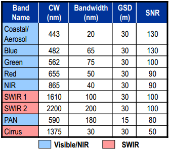
Additionally the ShortWave InfraRed (SWIR) bands are no longer covered with 60m ground resolution but have 30m.
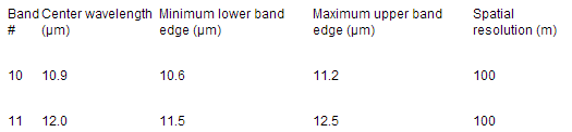
TIRS
The Thermal InfraRed Sensor is responsible for collecting thermal ground data. It doesn’t have the old resolution of 60m at ground but 100m. But that is not as bad as it looks like as TIRS will provide two thermal infrared bands:
You can get a nice mashup as well by watching this video:
I’ve collected some key literature you might be interested in here. Most of these articles are available for free.