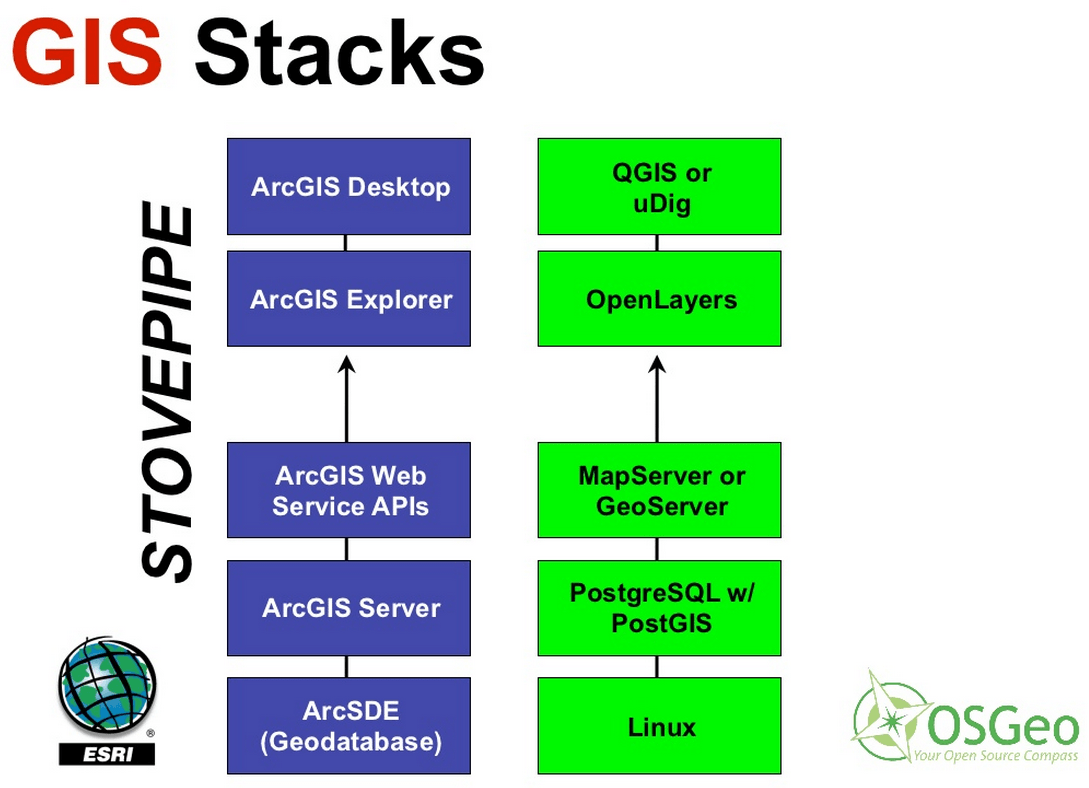
Which program is better suited to serve geographic data on the web? ArcGIS Server form ESRI or open source ? This question is common in mailing lists and GIS-forums. The most consistent answer is that depends on the project. But in this post we will see some numbers to determine which is the best software to develop an application for web mapping:GIS stacks from ESRI and OSGEO. Note the different bases of the graphic: left Linux, Windows/Linux on the right is missing! (source)
ArcGIS for Server
ArcGIS for Server was launched to replace ArcIMS, and its quality and functionality is unquestionable. In a way it is based on the flagship product of ESRI ArcGIS for desktop. But it has some disadvantages as well:
One ArcEditor license to configure and create data is required at least (price examples).
Use the REST API, but being based on DCOM objects have scaling problems.
each new API prob. means to renew the whole GIS-stack.
Why is open source GIS performing better?
MapServer or GeoServer run on all major operating systems (Windows, Linux, Mac OSX), ArcGIS for Server only works under Windows and Linux.
“Saving” of software licenses.
Satisfactory performance: for most needs the lean MapServer or GeoServer perform better than full equipped ArcGIS Server.
“Recently”, in June 2012, Jennifer R. Bauer has published an interesting academic work for a Master of Science in Geography, University of Oregon, which compares three web mapping applications and GIS desktop clients: MapServer, GeoServer and ArcGIS for Server.
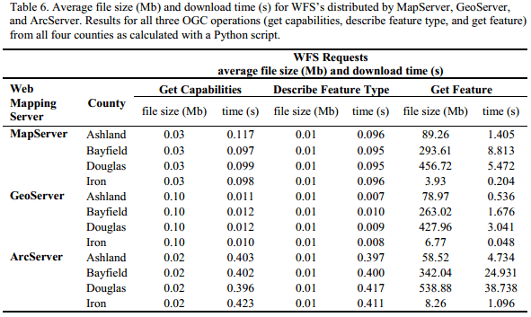
Although all three systems returned the same number of features, attributes and metadata for the test data sets, something was strange looking at download time and file size of given datasets:
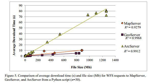
The most significant differences occurred in the operation GetCapabilities between GeoServer and the other two servers. File size generated by the servers regarding the geometry type and the request described, Getfeatures are similar with minor variations, but the WFS files created by ArcServer are larger than those created by MapServer and GeoServer.download speed and file sizes of given data sets in ESRI and open source GIS products for server environment. (Jennifer R. Bauer)download speed and file sizes in ESRI and open source GIS products for server environment. (Jennifer R. Bauer)
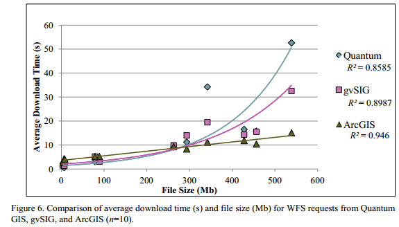
But as those requests were done by a python script we need to take a second look on the common consumer side: the Desktop GIS:
download speed and file sizes in ESRI and open source GIS products for desktop environment. (Jennifer R. Bauer)
This is only one study, in other analyzes ArcGIS for Server may have better results.
But mappinggis last statement is clear and we tend to support this statement:
“What is clear is that there is currently a trend in the industry to replace large facilities for ArcGIS Server to Open Source solutions and not vice versa.”
Good post. A fairer comparison might be ArcGIS Server feature layers vs WFS in the open source applications. Although ArcGIS Server supports WFS, in my experience most sites use Esri’s REST API with feature layers
[…] Here’s an article named ArcGIS server vs. Open Source GIS solutions […]
Jakub Kończyk
10 years ago
There is one more metric worth taking into consideration. The memory footprint of Mapserver is significantly lower than that of GeoServer mainly because of a different runtime environments they use. ArcGis probably would fall somewhere in between. Still the question of “which is the best software to develop an application for web mapping” only makes sense when you’ll precisely define what does the “best” mean in your particular case. Anyways, thanks for the post.
Sebastian Goerke
10 years ago
The most regretable thing about this comparison is that the most performant open source WFS (especially regarding rich GML), namely deegree, has not played any role within this investigation…
Hi Sebastian, thank you for your input. Unfortunately this research was done in 2012 and at this time I think the product of your company you are mentioning was not on the market, am I right? Contact us, if you want to write about deegree.
Thanks Sebastian for the clarification. Nonetheless I have never heard of deegree. I’ll have a look.
ps: sorry for the offensive words. I thought this was some kind of cheap advertisement…
[…] post ArcGIS server vs. Open Source GIS solutions appeared first on Digital […]
shinera ramlakhan
9 years ago
Hi all,
I am interested to find out which is better to use for the application concerned with mapping Telecommunication for GPON networks. This is a fiber network and using overhead cable design. I want to know which is better to use ArcGis or QGIS and can you tell me why? I am very concerned about security of data, integration of data, data storage and backup and data conversion capabilities. Thanks for the post.
Yes, almost all sites running ArcGIS Server are using arcgis REST API, there is no support from Geoserver or Mapserver for the arcgis REST API, while it is not a standard, it is superior. Take a look at http://www.cartologic.com/cartoview here if you use the cartoserver plugin you can serve up your data out with ArcGIS REST JSON and make good use of all adavanced ESRI client libraries.
Barascu Tudor
9 years ago
QGIS Server is also missing from the article but, indeed, Mapserver and Geoserver are more widely deployed.
Deepti Puri
8 years ago
Hi- I am looking at possible usage of Geoserver to replace ArcGIS Server for a web application. Jennifer’s article more than 3 years old. With ArcGIS 10.3 version- is the performance gain still so significant? I am looking for something recent- if you can speak from your experience- that will be great too.
Brian Davila
7 years ago
my business partner was needing OPM SF 15 last year and located a great service with lots of sample forms . If you are interested in OPM SF 15 also , here’s a https://goo.gl/PLs0ht.
JERRI HASSETT
7 years ago
Good article, Thanks!
Makani McDougall
6 years ago
http://www.bluespatial.com is another option. Blue Spatial implements the Esri REST API and is compatible with ArcGIS Desktop and all the SDKs.
This week the MOOC will concentrate on patterns and hypothesis about patterns. Exercises will concentrate on “hotspots” and patterns in crime analysis. So the keyword in this lessons…
Due to a recent article at our German partner geo-works.de I would like to share my two video tutorials for doing this. The first concentrates on the so…
[…] https://digital-geography.com%20.www378.your-server.de/diggeo/arcgis-server-vs-open-source-gis-solutions/?utm_campaign=twitter&am… […]
Good post. A fairer comparison might be ArcGIS Server feature layers vs WFS in the open source applications. Although ArcGIS Server supports WFS, in my experience most sites use Esri’s REST API with feature layers
[…] Here’s an article named ArcGIS server vs. Open Source GIS solutions […]
There is one more metric worth taking into consideration. The memory footprint of Mapserver is significantly lower than that of GeoServer mainly because of a different runtime environments they use. ArcGis probably would fall somewhere in between. Still the question of “which is the best software to develop an application for web mapping” only makes sense when you’ll precisely define what does the “best” mean in your particular case. Anyways, thanks for the post.
The most regretable thing about this comparison is that the most performant open source WFS (especially regarding rich GML), namely deegree, has not played any role within this investigation…
Hi Sebastian, thank you for your input. Unfortunately this research was done in 2012 and at this time I think the product of your company you are mentioning was not on the market, am I right? Contact us, if you want to write about deegree.
First of all thanks for this offer
Thanks Sebastian for the clarification. Nonetheless I have never heard of deegree. I’ll have a look.
ps: sorry for the offensive words. I thought this was some kind of cheap advertisement…
[…] post ArcGIS server vs. Open Source GIS solutions appeared first on Digital […]
Hi all,
I am interested to find out which is better to use for the application concerned with mapping Telecommunication for GPON networks. This is a fiber network and using overhead cable design. I want to know which is better to use ArcGis or QGIS and can you tell me why? I am very concerned about security of data, integration of data, data storage and backup and data conversion capabilities. Thanks for the post.
Yes, almost all sites running ArcGIS Server are using arcgis REST API, there is no support from Geoserver or Mapserver for the arcgis REST API, while it is not a standard, it is superior. Take a look at http://www.cartologic.com/cartoview here if you use the cartoserver plugin you can serve up your data out with ArcGIS REST JSON and make good use of all adavanced ESRI client libraries.
QGIS Server is also missing from the article but, indeed, Mapserver and Geoserver are more widely deployed.
Hi- I am looking at possible usage of Geoserver to replace ArcGIS Server for a web application. Jennifer’s article more than 3 years old. With ArcGIS 10.3 version- is the performance gain still so significant? I am looking for something recent- if you can speak from your experience- that will be great too.
my business partner was needing OPM SF 15 last year and located a great service with lots of sample forms . If you are interested in OPM SF 15 also , here’s a
https://goo.gl/PLs0ht.Good article, Thanks!
http://www.bluespatial.com is another option. Blue Spatial implements the Esri REST API and is compatible with ArcGIS Desktop and all the SDKs.