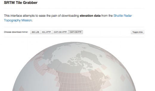
It’s been a couple weeks since I’ve posted here, but I just found something I wanted to pass along. If you work with geospatial data, you are probably familiar with the Shuttle Radar Topography Mission (SRTM) that collected elevation data over much of Earth. These data are available from a number of interfaces on the Web, but this is one of the nicest, and most innovative, ones I’ve found.
Just find the spot on Earth you are interested in and you can download the SRTM data for that area as a geotiff. I think this is probably based on a new(ish) technology called WebGL, but need to investigate a bit more. Hope it is useful for the DEM users in our audience.
Thanks for reading.
it has 100m resolution, on http://earthexplorer.usgs.gov/ is 30m…
Now you can download and clip a portion of the SRTM 30m DEM with one command with the elevation Python command line tool: http://elevation.bopen.eu/en/stable/quickstart.html
Install it with:
$ pip install elevation
Check if you have all the dependencies installed (mainly GDAL tools):
$ eio selfcheck
Download and clip a portion of the SRTM 30m DEM giving bounding box as WGS84 coordinates:
$ eio clip -o Rome-DEM.tif –bounds 12.35 41.8 12.65 42