How to build your own QGIS plugin
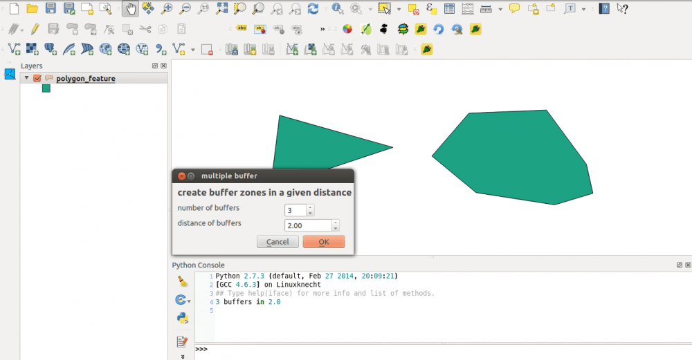
Since I’ve created the QGIS plugin qgis2leaf I was surprised how easy it is to create a plugin for QGIS. In this post I would like to show…
Since I’ve created the QGIS plugin qgis2leaf I was surprised how easy it is to create a plugin for QGIS. In this post I would like to show…
QGIS on Ubuntu Trusty Tahr I’ve have started working nearly 100%, outside of work, in Ubuntu. I was running Ubuntu 13.10 so naturally I decided to upgrade to 14.04. My experience…
Today I’ll start with a new series of tutorials for an open Source GIS called “ILWIS GIS“. ILWIS is the short term for “Integrated Land and Water Information System”…
Coursera, hail to Coursera. Despite the uprising criticism on MOOCs and their footprint in the educational landscape at universities Coursera created an interesting R learning course. It is…
Okay let’s be honest: I don’t have any idea of what D3 is capable off (we got Ralf for this crazy rocket science) but what Geoawesomeness posted today…
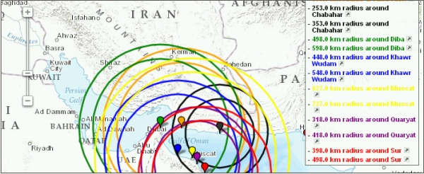
I looked for a program to draw circles of a pre-defined radius around some points on earth I had the coordinates from. A quick search returned the website…

Dear folks, most of you probably know how to map things using software on your pc. Some of you might also know cartoDB. We like their service as…
You probably already referenced maps with written coordinates but using photos or images is a little different as you need some characteristic points so you can control the…
When working with GIS and statistical data there is an emerging need to know some scripting language. Python is one of the most widely used. It is not…
Today QGIS 2.0 was officially released and we will come up with several tutorials in the next weeks. First of all: the installation. As we are fans of…

A short time ago I’ve posted an article on the installation of QGIS in combination with a PostGIS database in the background. As we all know, Windows is…
A lot of you out there are probably working on Windows Systems using ArcGIS and I have to admit that the possibilities with ArcINFO in the background and…